Scan to BIM Services in Wilsonville, Alabama
Wilsonville LiDAR to Revit for Waterfront, Lake-Area, Civic, and Residential-Commercial Documentation
AeroFrohne provides Scan to BIM services in Wilsonville, Alabama for waterfront property renovations, marina or visitor support spaces, civic and community facilities, and small commercial interiors. Around river and lake-area access, agricultural support sites, small commercial buildings, utility facilities, and community assets, project teams often need measured existing conditions before they commit to Revit modeling, CAD backgrounds, tenant improvement drawings, or facility record updates.
Wilsonville scopes can involve waterfront properties, community facilities, small commercial spaces, civic buildings, and support rooms, with field constraints such as weather windows, site access routes, occupied community spaces, and exterior context limits. Matterport Pro3 LiDAR helps capture room geometry, visible structure, ceiling conditions, and exterior context where permitted so architects, owners, and contractors can work from a defensible point cloud.
For Wilsonville projects, share the address, approximate square footage, floor count, access windows, target LOD, and whether you need Revit, CAD, E57, IFC, or a combined as-built package. AeroFrohne uses those inputs to align field capture, modeling scope, and turnaround expectations before scheduling.
- Alabama Field Coordination: Capture is planned around access windows, active operations, and client-defined site rules.
- Sample Deliverables: Revit Models (.RVT), 2D CAD Plans (.DWG), E57 Point Clouds, IFC Exports, and as-built documentation packages.
- Local Applications: Waterfront property renovations; Marina or visitor support spaces; Civic and community facilities; Small commercial interiors
Related Alabama scan-to-BIM pages: Birmingham, Pell City, Riverside, Lake View, Southside.
Pro3 LiDAR Specs for Wilsonville Projects
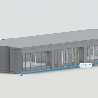
The Matterport Pro3 captures high fidelity depth data across Wilsonville waterfront interiors, community buildings, retail suites, support rooms, and exterior approaches where weather and access permit. It is a practical fit when teams need accurate geometry, visible MEP context, and scan-backed documentation before renovation or coordination work begins. We provide verified accuracy for your architects and engineers to work confidently in Revit, CAD, and point cloud review workflows.
Wilsonville Scan Deliverables
3D Scan to BIM
3D Scan to CAD
Standard Scan to BIM Deliverables
Revit Models (.RVT)
Intelligent 3D models of existing conditions. We model architecture, structure, and exposed MEP to your specified Revit version.
E57 Point Cloud
High density, registered point cloud files usable in Revit, Navisworks, Recap, and other BIM software for your own modeling teams.
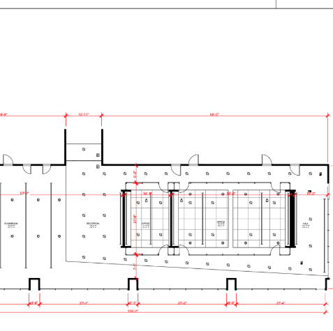
2D CAD (.DWG)
Floor plans, reflected ceiling plans (RCP), and elevations extracted directly from the 3D data for traditional CAD workflows.
IFC Exports
Industry Foundation Classes (IFC) exports for OpenBIM compatibility, ensuring data works across ArchiCAD, Vectorworks, and more.
LOD Specification
We tailor the geometry to your needs: LOD 200 (generic massing) to LOD 350 (precise geometry with connections/interfaces).
MatterPak™ Bundle
Includes .XYZ point cloud, .OBJ mesh file, and floor plan images for quick visualization alongside the heavy BIM data.
Who needs Scan to BIM in Wilsonville?
Waterfront and Lake-Area Assets
Document lake-area rooms, patios, common spaces, and exterior approaches before renovation or repairs.
- Waterfront as-builts
- Exterior context
- Renovation planning
Visitor and Community Facilities
Capture public-use rooms, offices, support spaces, and community facilities for owner records.
- Visitor facility records
- Community documentation
- Access-aware capture
Small Commercial Spaces
Create floor plans, point clouds, and CAD backgrounds for retail, service, and restaurant interiors.
- Commercial as-builts
- Tenant improvements
- CAD backgrounds
Civic and Utility Rooms
Support municipal, utility, and maintenance spaces with measured data for contractors and facility managers.
- Utility room records
- Civic updates
- MEP coordination
The Workflow: Local Capture to Global Standard
1) Plan Site Access
We coordinate Alabama field capture around weather windows, waterfront access, public-use schedules, and exterior capture permissions in Wilsonville, with the final access plan set by the client and property requirements.
2) Capture and Register
Scans are captured and registered into a unified point cloud (.E57). We clean noise and verify alignment to support structural, architectural, and MEP documentation.
3) Model to Scope
Our BIM technicians import the cloud into Revit and model walls, floors, openings, visible structure, and exposed MEP to the agreed LOD.
4) QC and Deliver
We overlay the model against the point cloud, review scope-specific tolerances, and deliver the native files, CAD exports, or as-built package requested.
Wilsonville BIM FAQ
What Wilsonville projects are a good fit for Scan to BIM?
Wilsonville projects involving waterfront properties, community facilities, small commercial spaces, civic buildings, and support rooms are strong candidates when the owner, architect, contractor, or facility manager needs measured existing conditions.
Can AeroFrohne work around occupied Wilsonville buildings?
Yes. Capture can be planned around weather windows, site access routes, occupied community spaces, and exterior context limits when the client provides access rules, operating hours, escort needs, and restricted areas before the field visit.
What deliverables can Wilsonville teams request?
Common deliverables include registered E57 point clouds, Revit models, CAD floor plans, reflected ceiling plan support, elevations, IFC exports, and as-built documentation packages.
How should I scope a Wilsonville Scan to BIM quote?
Send the Wilsonville property address, square footage, floor count, room list, target LOD, preferred software version, access windows, and whether the site needs phased or after-hours capture.
Can this Wilsonville page support nearby Alabama work?
Yes. AeroFrohne can scope nearby Alabama projects separately when each property has clear access, square footage, deliverables, and schedule requirements. Related pages include Birmingham, Pell City, Riverside, Lake View.