Scan to BIM Services in Georgetown, Georgia
Georgetown LiDAR to Revit: Coastal Residential and Commercial As-Builts
AeroFrohne provides precision Scan to BIM services in Georgetown Georgia, transforming real world environments into accurate digital models. While our headquarters is in Corpus Christi, we deploy dedicated contractors closest to the project site.
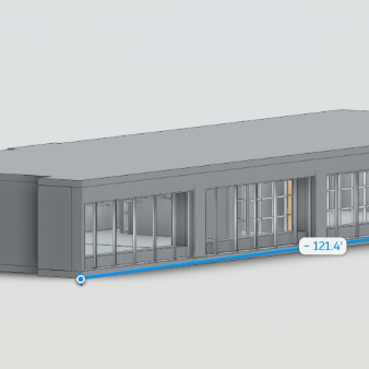
We use the Matterport Pro3 LiDAR camera to capture high density point clouds, which our team converts into LOD 200 Revit models (.RVT), CAD files (.DWG), or E57 point clouds. Whether you are documenting residential amenity spaces, retail centers, or coastal renovation projects in the Georgetown Metro Area, we deliver verified as-built data your design and construction teams can trust.
- Experienced Workforce: Deployed by regional technicians for fast turnaround.
- Deliverables: Revit Models (.RVT) • 2D CAD Plans (.DWG) • E57 Point Clouds • IFC Exports
- Applications: Residential Communities, Retail Centers, Coastal Renovations, MEP Coordination
Pro3 LiDAR Specs for Georgetown Projects
The Matterport Pro3 captures high fidelity depth data both indoors and outdoors, making it well suited for Georgetown project types including residential communities, retail centers, and coastal Georgia renovation projects. We provide verified accuracy for your architects and engineers to work confidently in Revit.
Georgetown Scan Deliverables
3D Scan to BIM
3D Scan to CAD
Standard Scan to BIM Deliverables
Revit Models (.RVT)
Intelligent 3D models of existing conditions. We model architecture, structure, and exposed MEP to your specified Revit version.
E57 Point Cloud
High density, registered point cloud files usable in Revit, Navisworks, Recap, and other BIM software for your own modeling teams.
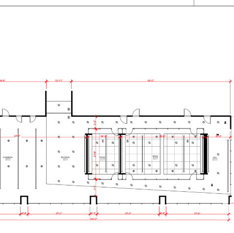
2D CAD (.DWG)
Floor plans, reflected ceiling plans (RCP), and elevations extracted directly from the 3D data for traditional CAD workflows.
IFC Exports
Industry Foundation Classes (IFC) exports for OpenBIM compatibility, ensuring data works across ArchiCAD, Vectorworks, and more.
LOD Specification
We tailor the geometry to your needs: LOD 200 (generic massing) to LOD 350 (precise geometry with connections/interfaces).
MatterPak™ Bundle
Includes .XYZ point cloud, .OBJ mesh file, and floor plan images for quick visualization alongside the heavy BIM data.
Who needs Scan to BIM in Georgetown?
Residential Communities
Capture amenity buildings, clubhouses, and multifamily interiors for renovation planning and facilities documentation.
- Existing-condition capture
- CAD and Revit-ready deliverables
- Construction coordination support
Retail & Office Spaces
Create CAD and Revit-ready as-builts for tenant improvements, fit-outs, and space planning.
- Existing-condition capture
- CAD and Revit-ready deliverables
- Construction coordination support
Coastal Renovation Projects
Document existing conditions before design, permitting, and contractor coordination begin.
- Existing-condition capture
- CAD and Revit-ready deliverables
- Construction coordination support
General Contractors
Use point cloud-backed models to coordinate trades and reduce field conflicts on compact project sites.
- Existing-condition capture
- CAD and Revit-ready deliverables
- Construction coordination support
The Workflow: Regional Capture to Global Standard
1) Deploy Regional Tech
We dispatch our regional contractor to your site. Fast mobilization for Georgetown, nearby Georgia communities, and surrounding project sites.
2) Process (Register)
Scans are registered into a unified point cloud (.E57). We clean noise and verify alignment to ensure structural accuracy.
3) Model (BIM)
Our BIM technicians import the cloud into Revit and trace geometry (walls, floors, pipes, beams) to the agreed LOD.
4) QC & Deliver
We overlay the model against the point cloud to verify accuracy, then deliver the native files to you.
Georgetown BIM FAQ
Do you have regional technicians in Georgetown?
Yes. While AeroFrohne HQ is in Corpus Christi, we have dedicated, trained contractors living in the region to service Georgetown, surrounding Georgia communities, and nearby commercial or civic project sites.
Can you scan active tech campuses or offices?
Yes. We can schedule scans during off hours or weekends to minimize disruption to your workforce, capturing precise as-builts for office retrofits or expansions.
What Level of Development (LOD) do you support?
We support LOD 200 (massing), LOD 300 (architectural/structural precision), and LOD 350 (fabrication detail) depending on your project requirements.
How long does it take to get the Revit model?
Scanning takes 1-2 days for typical sites. Modeling time depends on size and LOD complexity, usually ranging from 5 to 10 business days after scanning is complete.
How do I request a quote?
Visit our contact page. Please let us know the property is in the Georgetown area, the approximate square footage, and the desired deliverables (Revit vs. CAD).