Scan to BIM Services in Blue Diamond, Nevada
Blue Diamond LiDAR to Revit for Rural, Historic, and Visitor-Facing Assets
AeroFrohne provides Scan to BIM services in Blue Diamond, Nevada for rural historic structures, visitor facilities, trailhead-adjacent assets, small commercial buildings, and remote mobilization projects near Red Rock Canyon corridors. These scopes need a different tone than high-rise work because access, site conditions, and older-building geometry matter more than corporate campus assumptions.
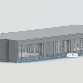
Matterport Pro3 LiDAR can document small commercial interiors, heritage structures, visitor-service rooms, exterior approaches, and irregular older spaces before preservation, adaptive reuse, or repair work begins. AeroFrohne can turn that capture into E57 point clouds, Revit models, CAD plans, elevations, and as-built packages for owners, architects, and contractors.
For Blue Diamond projects, share road access notes, square footage, power or access limitations, building age or preservation concerns, target LOD, and desired deliverables. Regional Nevada capture can be scheduled with remote-site logistics in mind so the field visit is efficient and complete.
- Regional Nevada Capture: Field coordination is planned around access windows, active operations, and client-defined site rules.
- Sample Deliverables: Revit Models (.RVT), 2D CAD Plans (.DWG), E57 Point Clouds, IFC Exports, and as-built documentation packages.
- Local Applications: Rural historic structures; visitor facilities; trailhead-adjacent assets; small commercial buildings; remote mobilization and adaptive reuse
Related Nevada scan-to-BIM pages: Summerlin South, Sloan, Las Vegas, Mount Charleston.
Pro3 LiDAR Specs for Blue Diamond Projects
The Matterport Pro3 captures Blue Diamond interiors, exterior context, historic rooms, visitor spaces, and small commercial properties where access permits. We provide verified accuracy for your architects and engineers to work confidently in Revit, CAD, and point cloud review workflows.
Blue Diamond Scan Deliverables
3D Scan to BIM
3D Scan to CAD
Standard Scan to BIM Deliverables
Revit Models (.RVT)
Intelligent 3D models of existing conditions. We model architecture, structure, and exposed MEP to your specified Revit version.
E57 Point Cloud
High density, registered point cloud files usable in Revit, Navisworks, Recap, and other BIM software for your own modeling teams.
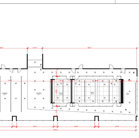
2D CAD (.DWG)
Floor plans, reflected ceiling plans (RCP), and elevations extracted directly from the 3D data for traditional CAD workflows.
IFC Exports
Industry Foundation Classes (IFC) exports for OpenBIM compatibility, ensuring data works across ArchiCAD, Vectorworks, and more.
LOD Specification
We tailor the geometry to your needs: LOD 200 (generic massing) to LOD 350 (precise geometry with connections/interfaces).
MatterPak™ Bundle
Includes .XYZ point cloud, .OBJ mesh file, and floor plan images for quick visualization alongside the heavy BIM data.
Who needs Scan to BIM in Blue Diamond?
Historic and Rural Structures
Document older walls, irregular rooms, porches, facades, and visible conditions for preservation or adaptive reuse.
- Historic as-builts
- Irregular geometry
- Adaptive reuse
Visitor and Trailhead-Adjacent Assets
Capture visitor-service spaces, support rooms, and nearby facilities where planning needs measurable context.
- Visitor facility records
- Trailhead-adjacent context
- Exterior approaches
Small Commercial Buildings
Create CAD and Revit-ready as-builts for local retail, service, hospitality, or office spaces.
- Small commercial capture
- Owner records
- Renovation planning
Remote Mobilization
Plan capture around access roads, site readiness, limited windows, and field logistics before the crew arrives.
- Remote-site planning
- Access notes
- Efficient field visits
The Workflow: Local Capture to Global Standard
1) Plan Site Access
We coordinate regional Nevada capture around remote access, historic conditions, site readiness, visitor hours, and weather or access constraints.
2) Capture and Register
Scans are captured and registered into a unified point cloud (.E57). We clean noise and verify alignment to support structural, architectural, and MEP documentation.
3) Model to Scope
Our BIM technicians import the cloud into Revit and model walls, floors, openings, visible structure, and exposed MEP to the agreed LOD.
4) QC and Deliver
We overlay the model against the point cloud, review scope-specific tolerances, and deliver the native files, CAD exports, or as-built package requested.
Blue Diamond BIM FAQ
Can AeroFrohne scan older Blue Diamond buildings?
Yes. Pro3 LiDAR capture can document irregular rooms, older walls, exterior context, and visible conditions for preservation, adaptive reuse, or renovation planning.
How do remote-site logistics affect capture?
Remote access, road conditions, site readiness, power availability, and weather windows should be shared before scheduling so the field visit is efficient.
What deliverables are useful for small commercial buildings?
CAD floor plans, Revit models, E57 point clouds, elevations, and as-built packages can support repairs, renovations, and owner records.
Can visitor facilities or trailhead-adjacent assets be documented?
Yes, where access is permitted. Visitor spaces, support rooms, exterior approaches, and nearby building context can be included in the scope.
What should I send for a Blue Diamond quote?
Send the address or site location, access notes, building size, preservation concerns, target LOD, and desired Revit, CAD, or E57 deliverables.