
Scan to BIM Services in Wake Forest, North Carolina
Wake Forest LiDAR to Revit: Existing Conditions for Growing Facilities
AeroFrohne provides Matterport Pro3 LiDAR Scan to BIM services in Wake Forest, North Carolina. We schedule trained capture technicians according to the project location, building access, and required deliverables.
For Wake Forest projects involving commercial interiors, schools and civic buildings, and multifamily renovations, we capture existing conditions and convert registered point clouds into Revit models (.RVT), CAD files (.DWG), IFC exports, or E57 point clouds. Nearby service coverage includes Rolesville, Youngsville, and Franklinton.
- Project planning: Capture scope, access windows, LOD, file formats, and coordinate requirements are confirmed before mobilization.
- Deliverables: Revit Models (.RVT) • 2D CAD Plans (.DWG) • E57 Point Clouds • IFC Exports
- Applications: commercial interiors, schools and civic buildings, multifamily renovations, and construction coordination
- Coverage: Wake Forest, North Carolina, plus nearby Rolesville, Youngsville, and Franklinton.
Pro3 LiDAR Specs for Wake Forest Projects
Matterport Pro3 captures high-density depth data indoors and outdoors for commercial, civic, and multifamily projects. The registered point cloud supports coordinated architecture, structure, and visible MEP modeling in Revit.
Explore the RVT Model in 3D
Wake Forest Scan Deliverables
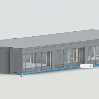
3D Scan to BIM
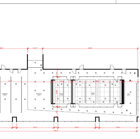
3D Scan to CAD
Standard Scan to BIM Deliverables
Revit Models (.RVT)
Intelligent 3D models of existing conditions. We model architecture, structure, and exposed MEP to your specified Revit version.
E57 Point Cloud
High density, registered point cloud files usable in Revit, Navisworks, Recap, and other BIM software for your own modeling teams.
2D CAD (.DWG)
Floor plans, reflected ceiling plans (RCP), and elevations extracted directly from the 3D data for traditional CAD workflows.
IFC Exports
Industry Foundation Classes (IFC) exports for OpenBIM compatibility, ensuring data works across ArchiCAD, Vectorworks, and more.
LOD Specification
We tailor the geometry to your needs: LOD 200 (generic massing) to LOD 350 (precise geometry with connections/interfaces).
MatterPak™ Bundle
Includes .XYZ point cloud, .OBJ mesh file, and floor plan images for quick visualization alongside the heavy BIM data.
Who needs Scan to BIM in Wake Forest?
Architects & Engineers
Document existing geometry for commercial interiors in Wake Forest before renovation design, coordination, or code review.
- Existing-conditions modeling
- Revit design backgrounds
- Visible MEP documentation
Owners & Facility Teams
Build a reliable digital record for schools and civic buildings, space planning, maintenance coordination, and capital projects.
- Facility documentation
- Space and asset planning
- Renovation handoff
Contractors & VDC Teams
Coordinate Wake Forest project conditions with registered point clouds, CAD as-builts, and Revit models before field work begins.
- Pre-construction planning
- Clash and access coordination
- Construction verification
Renovation & Adaptive Reuse
Capture irregular, occupied, or undocumented spaces without relying on incomplete legacy drawings.
- Facade and interior documentation
- Adaptive-reuse planning
- As-built record creation
The Workflow: Local Capture to Global Standard
1) Schedule Capture
We coordinate the Wake Forest site access, scan areas, control requirements, and deliverables before mobilization. Nearby coverage includes Rolesville, Youngsville, and Franklinton.
2) Process (Register)
Scans are registered into a unified point cloud (.E57). We clean noise and verify alignment to ensure structural accuracy.
3) Model (BIM)
Our BIM technicians import the cloud into Revit and trace geometry (walls, floors, pipes, beams) to the agreed LOD.
4) QC & Deliver
We overlay the model against the point cloud to verify accuracy, then deliver the native files to you.
Wake Forest BIM FAQ
Can AeroFrohne provide Scan to BIM services in Wake Forest?
Yes. AeroFrohne schedules trained capture technicians for projects in Wake Forest and nearby communities such as Rolesville, Youngsville, and Franklinton. Mobilization depends on site access, project size, and required deliverables.
Can you scan occupied buildings in Wake Forest?
Yes. Capture can be scheduled around building operations, including off-hours when practical, to reduce disruption while documenting existing conditions.
What Level of Development (LOD) do you support?
We support LOD 200 for general geometry, LOD 300 for design-intent geometry, and LOD 350 for coordination interfaces, depending on the agreed project requirements.
How long does it take to receive the Revit model?
Field and modeling schedules depend on square footage, access, complexity, and the requested LOD. AeroFrohne confirms the expected capture and delivery schedule in the project quote.
How do I request a Scan to BIM quote for Wake Forest?
Use the contact page and provide the Wake Forest project address, approximate square footage, site-access constraints, and required deliverables such as Revit, CAD, IFC, or E57.