AeroFrohne provides precision Scan to CAD services in Larkspur, Colorado by capturing existing conditions with
the Matterport Pro3 LiDAR camera and converting the registered data into clean, usable CAD documentation.
AeroFrohne coordinates local and regional capture for Larkspur projects and can deploy nationwide for larger scopes.
We support owners, architects, engineers, contractors, facility teams, and developers that need dependable
DWG floor plans, reflected ceiling plans, elevations, sections, and point cloud-backed as-built drawings.
Larkspur sits in the wooded Front Range corridor between Denver and Colorado Springs, with custom homes, equestrian acreage, ranch buildings, and event or hospitality properties. Scan to CAD can document a main structure together with additions, barns, finished lower levels, and complex interior volumes before renovation or change-of-use design.
Capture Method: Matterport Pro3 LiDAR scanning with registered point cloud verification
Larkspur Scan to CAD Specs
Our Larkspur Scan to CAD workflow is designed for fast field capture and practical design-team delivery. We register scan data, review geometry, and translate existing conditions into CAD files tailored to local project constraints, access windows, and permitting timelines.
Primary OutputDWG / 2D CAD
Capture PlatformMatterport Pro3 LiDAR
Accuracy Reference±20mm @ 10m
Scan to CAD Near Larkspur, Colorado
Coordinated Colorado coverage is also available for Palmer Lake, Monument, Woodmoor, and Gleneagle. Each location page explains how LiDAR-to-DWG documentation supports the local building types and renovation conditions found there.
Larkspur Scan Deliverables
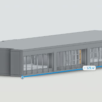
3D Scan to CAD
LiDAR Capture Workflow
Commercial Real Estate Scan to CAD Sample PDFs
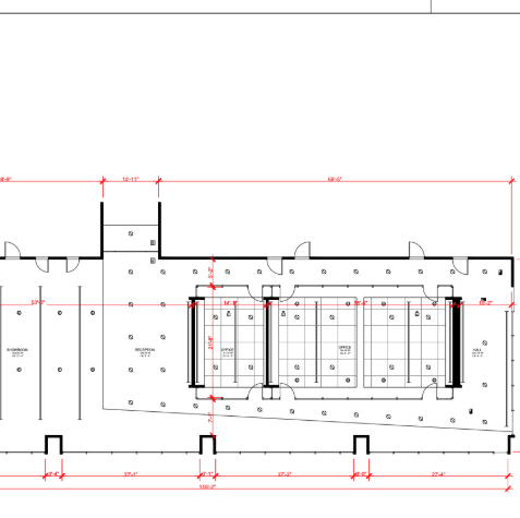
Review actual A2 PDF deliverables from a commercial real estate Scan to CAD workflow. The sample set includes a first-floor as-built plan and a reflected ceiling plan with measured room areas, ceiling heights, red dimensions, furniture, architectural elements, electrical symbols, project scale, and a Matterport source reference.
A2 PDF Sample
First-Floor As-Built CAD Plan
A 4,381.95 SF first-floor drawing with overall dimensions, showroom, reception, office and hall areas, ceiling heights, furniture layout, architectural elements, and electrical index symbols.
A companion reflected ceiling plan showing overhead conditions, fixture and electrical symbol locations, room areas, ceiling heights, red dimensions, project scale, and the same Matterport source reference.
Dimensionally organized floor plans based on existing field conditions for renovation, planning, and lease documentation.
Reflected Ceiling Plans
Ceiling grids, soffits, lighting layouts, and overhead conditions captured for coordination and design updates.
Elevations
Interior and exterior elevation views extracted from registered scan data for wall studies, storefronts, and finish documentation.
Building Sections
Section cuts that help teams understand vertical relationships, mezzanines, ceiling heights, shafts, and structural transitions.
E57 Point Clouds
Registered point clouds delivered when the design team wants the raw or processed spatial data alongside the CAD package.
Existing Conditions Packages
Combined drawing sets for renovation and facility scopes that need a dependable as-built baseline before design begins.
Who needs Scan to CAD in Larkspur?
Local Properties & Renovations
Useful for custom residences, equestrian facilities, ranch buildings, event venues, hospitality properties, and offices that need coordinated as-built plans.
Existing-condition verification
Renovation design baseline
Addition and reuse planning
Industrial & Energy Facilities
Ideal for warehouses, process facilities, and industrial sites where accurate field conditions reduce rework and coordination risk.
Plant documentation
Equipment area capture
Maintenance planning
Healthcare & Education
Supports phased renovations and occupied-building workflows where teams need existing conditions without relying on outdated legacy drawings.
Phased access capture
Renovation baselines
Facility archives
Multifamily & Hospitality
Strong fit for property repositioning, corridor upgrades, amenity remodels, unit prototypes, and renovation takeoff preparation.
Existing unit plans
Common area documentation
Renovation coordination
The Workflow: Capture, Register, Draft, Deliver
1) Site Capture
We scan the site using Matterport Pro3 LiDAR to document geometry, circulation, wall faces, ceiling conditions, and existing room relationships.
2) Point Cloud Registration
The scans are processed into a unified spatial dataset. We review alignment and overall coverage before the drafting phase begins.
3) CAD Drafting
We convert the scan data into practical CAD drawings such as DWG floor plans, RCPs, elevations, and sections based on the agreed scope.
4) QC and Delivery
We perform drawing checks against the scan data, package the deliverables, and issue the final CAD files for design or facilities use.
Larkspur Scan to CAD FAQ
What files do you usually deliver?
Typical deliverables include DWG floor plans, reflected ceiling plans, elevations, sections, and registered E57 point clouds depending on the scope and downstream design needs.
Can you scan occupied buildings or active job sites?
Yes. AeroFrohne can schedule around occupancy, active construction, shutdown windows, and phased access requirements to minimize disruption.
Is Scan to CAD better when we only need drawings and not a full BIM model?
Yes. If the project mainly needs as-built drawings for planning, renovation, coordination, or facilities, Scan to CAD is often a more efficient and cost-effective deliverable than full Revit modeling.
Do you only serve Larkspur?
No. AeroFrohne serves Larkspur, Douglas County, southern Douglas County and the Front Range corridor, and can coordinate regional or nationwide deployment depending on project scope and site access.
How do I request a quote?
Visit the AeroFrohne contact page and send the site location, approximate square footage, access constraints, and the specific CAD deliverables you need.
Can I review sample PDF deliverables before requesting a quote?
Yes. This page includes public commercial real estate PDF samples for a first-floor as-built plan and a reflected ceiling plan so project teams can inspect the drawing format before requesting a quote.